Featured Maps

Pictorial Map of Fresno County & Mid-California's Garden of the Sun
c1923
The anonymous bird’s-eye view, which extends north to San Joaquin, south to Kern, and west to Gala Veras, Tuolumne and Mariposa counties, is surrounded by 31 mostly photographic vignettes illustrating landmarks, natural resources and industries....

The first map dedicated to Australia in English
1744-1748
Tasman’s map of New Holland was first published in Melchisedech Thevenot’s 'Relations de divers voyages curieux' in 1663 and then revised until 1696. “Thevenot ensured that his book included maps at every juncture. Of t...

Anchorage & Cook Inlet, Alaska
1983
Published for the ALASKA GEOGRAPHIC (Vol 10, Number 2), this colorful map covers from Anchorage to Seward and NE to Mt McKinley (Denali name not yet present).This is one of the better examples of this genre. Susan Schumacher (who was on the maga...

Geographiae opus novissima traductione a Grecorum archetypis castigatissime pressum
1513
This is one of the most important editions of Ptolemy's geography, containing many new regional maps: twenty new maps based on contemporary knowledge "unlike many of the alleged 'new' maps produced by earlier editors, [they] contained a ...

Wild Bill Hickok Treasure Map
1952
The legend on the map states that it “locates many of the better known treasure sites of the United States. They are scattered from coast to coast… in the denseness of metropolitan centers, in the sands of a hundred islands and in the deso...

Map of the United States completely surrounded by Texas
1949
“Holly-Wood-Fornia”, “Knee-va-dugh”, and “Arid-zona”…This witty map, full of bold exaggerations as to how Texas is the biggest and best, and making terrible puns at the expense of the rest of the US, was issue...

UAT Route Map of Africa
c1956
“la plus importante compagnie privee Francais de transport aerien”This colourful poster map was created for ‘UAT Aeromaritime’, a French airline originally founded as ‘Aeromaritime’ in 1937 by the shipping line Les Chargeu...

Hydrographical Chart of the World According to Wright's or Mercators Projection
1814
Arrowsmith's towering achievement of English cartography of the early 19th century: arguably the most advanced and detailed map of the world available at the time, and a superb example. A map of great scale on eight, unfolded, elephant-folio sheets-it wo...

Dai Nihon Dochu Saikenzu (Japan)
1882
Large color-printed engraved map of Japan on three sheets joined. 14x57 inches overall, folding into original self-wrappers with printed paper label; covers a bit worn, map excellent. A fine Meiji map of Japan profusely illustrated with over 70...
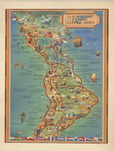
Pan Am. On the Routes of the Flying Clipper Ships
1949
Pictorial map of North and South America. Covers from San Francisco to south of Buenos Aires. showing the routes of Pan American Airways "Flying Clipper Ship" routes, a commercial airline service in operation from 1931 to 1946. The fl...
