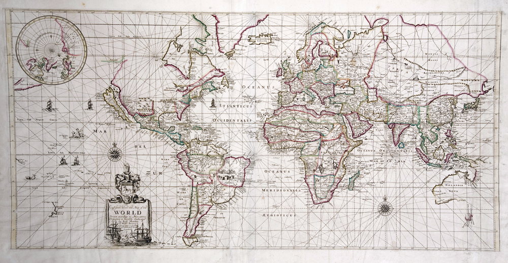
World Map
Cartographer:
Morden, Robert & Berry, William
Date of Creation:
1676
World Map, Robert Morden and William Berry, 1676 (1682)
To Capt. John Wood this Map of the World Drawn according to Mercators Projection is Humbly Dedicated By Robt. Morden & Willm. Berry. Sold at ye Atlas in Cornhill & at ye Globe in ye Strand London. Copperplate engraving on two sheets, joined.
Until the seventeenth century, navigators contended with the problem that a plotted straight line on a sea-chart did not represent a “straight” line of sailing on the spherical earth. In 1569 Gerhard Mercator introduced a map projection which now bears his name and which attempted to solve this problem. On his projection, all parallels and meridians intersect at 90 degree angles, and latitudinal distance from the equator progressively lengthens. The resulting visual distortion of this projection, however, slowed its acceptance by pilots, and this barrier was exacerbated by Mercator’s imprecision. The calculation of distances on the projection was tricky, and it was not until thirty years after Mercator’s experimental map that an Englishman, Edward Wright, devised more accurate tables for this purpose.
The Mercator projection became popular among chart makers in the French port of Dieppe, on the English Channel, by about 1630. It was not widely used on printed maps until Robert Dudley’s sea atlas, Arcano del Mare, all of whose charts are constructed on the projection. His chart of New Netherlands and New England is typical of the Arcano in that it contains other information geared for actual navigation – prevailing winds, magnetic variation, and ocean currents.
Dudley’s furthest experience at sea was a voyage to Guyana in 1594. Although as a youth he had wished to travel to the Pacific, this aspiration was nixed by the Queen. The “illegitimate” son of the Earl of Leicester, at about age thirty he claimed legitimacy and inheritance because of a rumor that his parents had been secretly married. But his insistence brought the wrath of the Countess of Leicester, who accused him of conspiracy and defamation. He fled England for France, leaving behind his (third!) wife but taking with him his cousin Elizabeth, disguised as a page. In France the two declared themselves Catholic and were married. They continued to Italy, asked the Grand Duke of Tuscany for protection, and passed their lives in exile in the region of Florence. The meticulously crafted and expensively produced Arcano del Mare was finished only at the end of his life; he died in 1649.
The London mapmakers Robert Morden and William Berry used the Mercator projection for this world map, which bear some stylistic similarity to the 1599 world map prepared by Edward Wright, the Englishman who refined the projection’s mathematics.
Captain James Wood, to whom the map is dedicated, was the leader of an expedition in search of the Northeast Passage. The voyage ended in shipwreck in 1676 – but its narrative gained fame for quite different phenomena, that of the study of the color and transparency of ocean water.
From our perspective in the twenty-first century, perhaps the most remarkable aspect of this and other world maps from the late seventeenth century is how “correct” they look to us. A mere two centuries since the ambitions of Spain and Portugal catapulted Europe into obsessive trans-oceanic exploration, enough had been learned about the general outlines of the continents that they look familiar to us today.
