Featured Maps
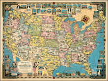
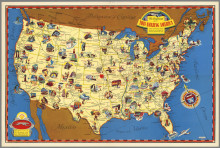
America the Wionderland
1941
An updated and more richly illustrated sequel to an earlier monochrome map by Chase The United States of America (1935), filled with an abundance of illustrations of buildings and landmarks, natural resources, scenic highlights and other attractions. &l...
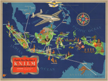
Complete Map of the Airlines of K.N.I.L.M
c1935
Featuring a Lockheed Model 14 Super Electra, or “Lockheed 14”, the flagship of the KNILM passenger fleet, soaring over the East India archipelago and parts of Southeast Asia, formerly the Dutch East Indies, and now modern Indonesia. The rout...
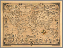
World Wonders. A Pictorial Map
1939
Chase’s Wonders of the World, include: engineering, architectural and artistic achievements of mankind through the ages, as well as marvels of nature; the Statue of Liberty, Empire State Building, Mayan temples, Egyptian Sphinx, Great Wall of China, K...
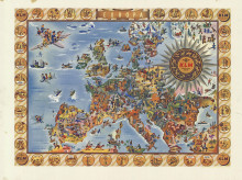
KLM Europa
c1958
Colorful and incredibly busy advertisement for the Dutch Royal Airline. Large Compass Rose/cartouche in the right corner showing all the signs of the zodiac. The map is surrounded by vignettes, perhaps a nod to the earlier Dutch mapmakers. The name ...
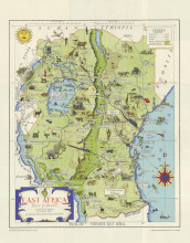
East Africa. Land of Sunshine
1949
This lively map of East Africa, includes modern day Kenya, Tanzania, Zanzibar, and Uganda. Centered on the Rift Valley, which is colored in a darker green, the map covers from Lake Tanganyika to the Indian Ocean and from the Sudan/Ethiopia border to...
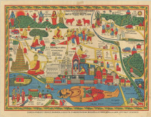
Map of Gaya
2nd half 20th-century
This vibrant pictorial map of Gaya in India is oriented with west at the top, the title and place names are in English and in Hindi, the whole is surrounded by a border of vine-leaves.The map, possibly designed for those on a religious pilgrimage, cen...

Fun Map of New Zealand
1940
Issued by the New Zealand Government Tourist Bureau and printed by E.V. Paul after designs by Charles Haines, the first advertising agency in New Zealand, founded by Haines in 1891. While the promotional material on the verso of the map is designed to...
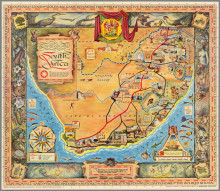
A Pictorial Map South Africa
1950
This charming souvenir map was created by Bernard Sargent for the South African Tourist Corporation. The map shows the major roads and the sites that can be seen along those roads, representing "diverse places and extraordinary manner of strange ...
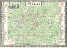
Central Map of Tehran
1961
A comprehensive plan of central Tehran, the Key identifies the locations of all the Government Ministries, embassies and legations, travel agencies, hotels, museums, bookshops, banks, libraries, “Important Trading Houses”, “Commercial Counsell...
The Greyhound Map of This Amazing America. Natural and Man-Made Wonders...
1941
One in a series of pictorial maps done by Greyhound to advertise and promote travel by bus. Wartime events would soon put severe limits to recreational travel. In addition to the colorful vignettes, the text on the verso is a numbered index o...
