Featured Maps
Map of the University of California
1939
Beautifully designed map of the University of California, extending to the Berkeley, San Francisco, Los Angeles, Riverside, La Jolla, Mt. Hamilton and Davis campuses.“This Map of the University of California sponsored by The California Club in commemo...
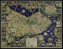
Colour of an Old City: A Map of Boston Decorative and Historical
1926
Houghton Mifflin’ first pictorial map and Clark and Olsen’s first joint venture, which they began in September of 1925: “spending six months of ‘exhaustive study and incessant sketching’, with much research taking place in...

A Hysterical Map of Yellowstone Park and the Jackson Hole Country. Slightly Cockeyed.
c1936
First issue, subsequently printed as a King Size mapcard in the 1950s. The Lindgren’s humorous pictorial map "Drawn in Broken English by Jolly Lindgren" features highlights of the area of the Jackson Hole country and Yellowstone National Pa...
Lake George and Lake Champlain
1926
"The Charm and Beauty of Lake George and Lake Champlain Can Be Fully Enjoyed Only from the Steamer's Deck"Two elegant maps, one shows both lakes from Albany to Montreal, and the other Lake George and environs in more detail. The former is s...
Southern Pacific Lines follow the trails blazed by the pioneers
1928
An uncommon and visually appealing map poster "done in the old style" with decorative galleons and sea monsters and an elaborate compass rose. Southern Pacific's Shasta Route, Overland Route, Golden State Route and Sunset Route are marked, &q...

Panair do Brasil. Nos Ceus de Tres Continentes. A Frota Bandeirante
1947
Eymonnet’s vibrant map, heightened in gold, is very much in the style of the planispheres created by Lucien Boucher for Air France. The image shows the origin of airline in Brazil and the many destinations that it reached at the time of the map. It...
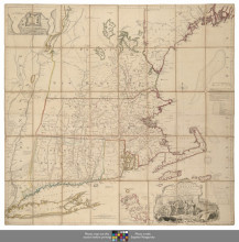
A Map of the most Inhabited part of New England
1755
The very rare first state, with “Konektikut” in the title, of the pre-eminent eighteenth century map of New England, and of great geographic and political significance. Issued in 1755, Green’s 'Map of the Most Inhabited Part of...
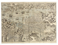
Hishu Nagasaki zu
1778
A superb map of Nagasaki, and one of the earliest examples of printing from the city.The upper and lower halves were each printed from two large woodblocks (one for the main map image in black including the outlines of the buildings and land; and the tint...
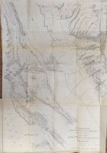
A Correct Map from Actual Surveys and Examinations Embracing a Portion of California between Monterey and the Prairie Butes in the Valley of the Sacramento Shewing the Placeres, 1849
1849
Published in Wilkes' 'Western America, Including California and Oregon, with Maps of Those Regions, and of 'The Sacramento Valley', Philadelphia: Lea and Blanchard, 1849, and one of three large folding maps included in the volume. &l...
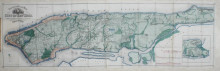
Topographical Map of the City of New York
1865
"The most enduring nineteenth-century map of Manhattan is Egbert Ludovicus Viele's Water Map, which was first published in 1859 and is still in use today” (Augustyn & Cohen).Viele’s iconic map of New York: 'Topographical Map of the City...
