Featured Maps

Ragbrai XIV
1986
Number 78 of 500 numbered copies signed by Blattel-Britton. Created to coincide with the XIVth annual RAGBRAI [Register’s Annual Great Bicycle Ride Across Iowa], 400 mile bicycle touring race from Mineola to Muscatine: the largest Bike-touring ev...
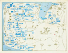
La Jolla "The Jewel"
1968
A delightful and quite scarce pictorial of the Village and vicinity in 1968. Covers as far south as Bird Rock and North to the Torrey Pines Golf Course which is noted as “Golfer’s Paradise”. Perhaps not surprisingly, many of the esta...
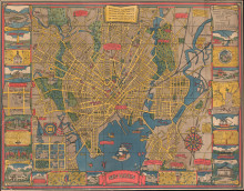
New Haven
1928
Carina Eaglesfield Mortimer Milligan (1890-1978) was an American architect, who joined Anne Morgan (1873-1952)’s Comite Americain de Secour Civil / CASC, during WWII, after the death of her first husband. Unlike most young architects, Eaglesfi...

East Africa Land of Sunshine (Kenya, Uganda, Tanganyika)
1949
Depicting modern day Kenya, Tanzania, Zanzibar, and Uganda, the map extends from Lake Tanganyika to the Indian Ocean and from the Sudan/Ethiopia border to the Ruvuma River. The map features many of East Africa’s Great Game parks: the Seren...

"Hysterical Map of Yellowstone ...."
1948
The “Famous Hysterical Map of Yellowstone Park including a few minor? Changes”, was first published in 1936. "Hatched & Scratched by Jolly Lindgren", it includes most of the humor of the previous iterations, and includes...

"Meddo" Sea Chart-Marshall Islands
c1920
This ‘Meddo’ sea chart from the Marshall Islands, where navigation was, and still is, an essential survival skill, was a closely guarded secret and only passed on within a small number of families. In order to memorise the main navigational...

Didactic Manuscript Map of Africa
c1813
An exceptional manuscript composition most likely done in, or for, a German school classroom. The central map of Africa is surrounded by finely detailed vignettes including a coastal view of the mountains from the south-east coast, exotic natural history ...
You've Only Got to Choose Your Bus
1920
Created for the London General Omnibus Company, Gill's map, centred on Reigate, of the bus routes in the area between Epsom and Horley, north to south, and Godstone to Effingham, east to west, is illustrated in the same medieval modernist manner as...

Northwest Orient Airlines System Map
1947-1949
Pictorial route map for Northwest Orient Airlines, issued between 1947, when NWA began flying to Tokyo, Seoul, Manila, and Shanghai, and 1949 when they suspended flights to Shanghai (See Northwest Airlines History Center for similar route maps of the p...
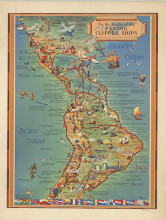
Pan Am. On the Routes of the Flying Clipper Ships
1949
Pictorial map of North and South America. Covers from San Francisco to south of Buenos Aires. showing the routes of Pan American Airways "Flying Clipper Ship" routes, a commercial airline service in operation from 1931 to 1946. The fleet began in 1...
